Table of Contents
Hazards are part of the world around us and their occurrence is inevitable. Floods, landslides, wildfires, windstorms, and other hazardous events are natural phenomena in Colorado over which humans have limited control. These events result in periodic damage to the environment: fire can destroy forests, floods can erode stream banks and result in channel migration, and a host of geologic hazards can severely alter the natural landscape. However, despite their destructiveness, these occurrences are not unexpected, and can even reflect healthy regeneration of natural systems.
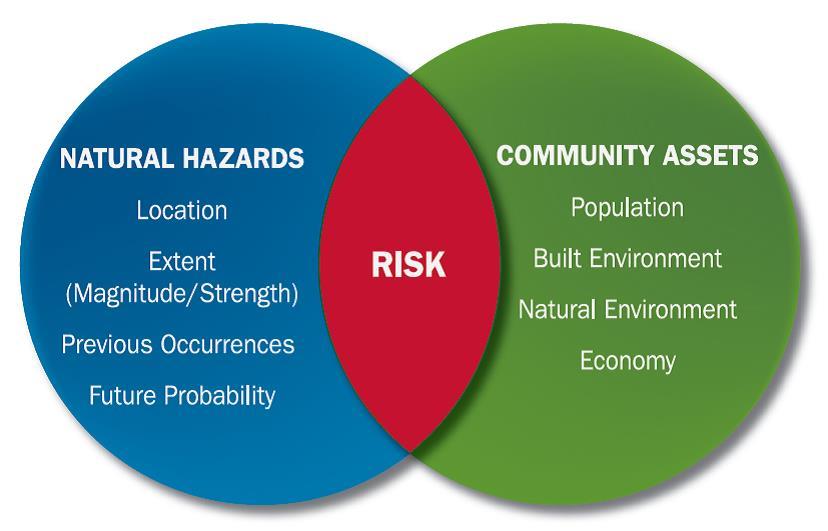 It is only when the human environment intersects with these natural phenomena that a hazard risk is created and a so-called “natural disaster” may result. A disaster occurs when human settlement and infrastructure, such as buildings and roads, exists in the path of the forces of nature, resulting in potentially hazardous situations. Our built environment is not nearly as recuperative or resilient as the natural one. A hazard can result in physical damage, economic disruption, and other significant impacts to an entire community for many years following the event.
Disasters can also occur as a result of human activity, such as the storage or movement of hazardous chemicals, regardless of natural conditions. While the source or cause of risk and disasters may be natural or human-caused, this planning guide focuses primarily on Colorado’s most significant natural hazards.
While we cannot prevent natural hazards, we do have some means to anticipate their occurrence and manage what comes afterward—and we certainly can minimize the risk from human-caused hazards. Local planners in particular have a range of tools and techniques to minimize or avoid the potential adverse consequences from foreseeable hazards. The focus of this guide is to assist citizens in planning ahead before a hazard event occurs, so that communities can lessen risk and hopefully prevent hazardous events from becoming disasters.
The first step in preparing for hazards is to conduct a local risk assessment, which helps identify the potential impacts of hazards on a community’s physical, social, economic, and environmental assets. When done correctly, the assessment helps decision makers and stakeholders understand the most locally significant hazards and unique risks, including current and possible future vulnerabilities. Just as important, the risk assessment supports the development of mitigation measures to reduce future risk. While specific approaches may vary depending on available capabilities and resources, the outcome, conclusion, or end goal of any meaningful risk assessment should be implementation of the community’s risk reduction and mitigation strategies.
Involving Everyone in Risk Assessment
Identifying local hazards and assessing risk requires input from a number of stakeholders and data from a variety of sources. This will include plans and personnel that might not immediately come to mind.
A collaborative, multi-sector, inclusive process is necessary. For example, a risk assessment should engage fire service and emergency managers, community planners, city engineers, law enforcement, regulators, natural resource and/or hazard experts (geologists, foresters, hydrologists, floodplain managers, fire behavior analysts, etc.), GIS specialists, community leaders, local residents, community organizations, and others. Similarly, data sources may include the Local Hazard Mitigation Plan, emergency management plan, comprehensive/master plan, hazard-specific plans and historical data, critical infrastructure plans, census information, and any other resources that help describe the hazard and identify community assets (or “values at risk”).
Some information is not up for debate—historical analyses of flood or fire, for example, is factual. Other inputs, including values and estimated losses, can become more subjective. While finding consensus may be difficult, the process of engaging multiple stakeholders ensures that everyone better understands the risk assessment outcomes and is better prepared to help prioritize mitigation efforts. Building these relationships before a disaster occurs will also pay dividends during and after the disaster.
Developing Your Own Local Risk Assessment
Early in developing a risk assessment, planners should collect and review local sources that have already addressed local hazards. The sources will likely be many and varied in terms of their relevance, accuracy, and usefulness, so the first key action is to collect and review what is readily available. This may include emergency operations plans, comprehensive plans, natural resource plans, or hazard-specific plans (e.g., floodplain management plans, community wildfire protection plans) if available, as well as any other technical reports or studies.
We Don’t Have GIS. How Can We Map our Hazard Risk?
For many communities in Colorado, the use of GIS is either cost-prohibitive or otherwise limited by resources or expertise. There are several options to explore to help communities establish a more robust spatial analysis of hazards without the use of GIS.
-
Contact the state. The Division of Homeland Security and Emergency Management is familiar with available mapping resources, and can point communities in the right direction to locate already existing maps. Contact the local hazard mitigation planning program manager at dhsem.state.co.us/emergency-management/mitigation-recovery
-
Generate free maps online. Link to online resources that provide free data, and many of them can be mapped to the region or even local level depending on the hazard. One example: EPA’s MARPLOT, which is the mapping program for the CAMEO software suite, which is used widely to plan for and respond to chemical
emergencies. Learn more about the CAMEO software suite at epa.gov/cameo/marplot-software. -
Establish an IGA for shared GIS services. Working with a neighboring municipality or county that is already equipped with GIS can be an efficient and affordable way to secure accurate hazard mapping analysis. An intergovernmental agreement (IGA) can define the parameters of the work, assign responsibilities, and establish requirements for any monetary contributions.
-
Contact a University. Undergraduate or graduate programs in urban planning or geography may have students or classes interested in assisting with your hazard identification and risk assessment mapping needs.
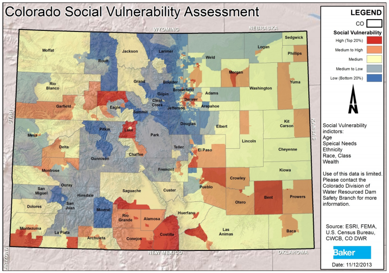
Another important element of the risk assessment is identifying any particularly vulnerable populations in the community. The consequences of a disaster event extend well beyond physical damages, often causing or amplifying human suffering, economic loss, and social disruption. This is especially true for those who may not easily access the resources typically offered to assist with individual actions before, during, or after an emergency or disaster event.
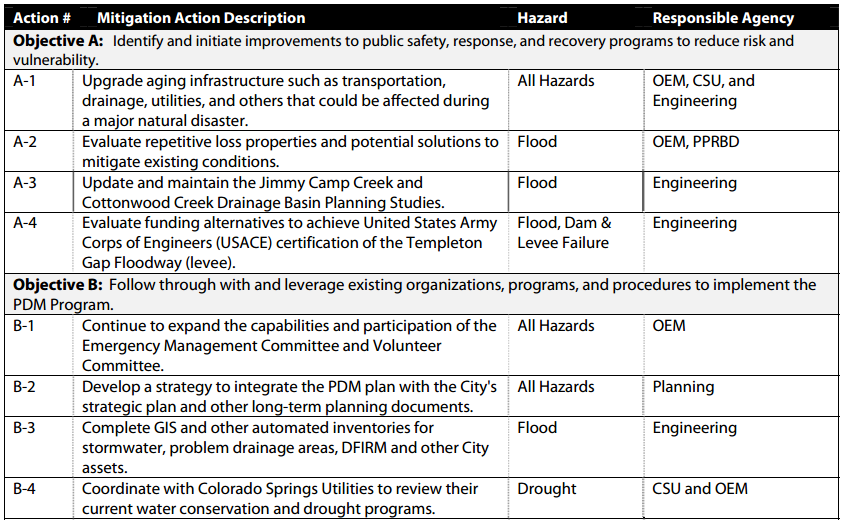
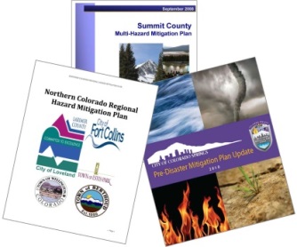
What Are Local Hazard Mitigation Plans and Why Are They Important?
Local Hazard Mitigation Plans consolidate all the hazard-related information prepared by the community, including descriptions of potential hazards, risk assessments, identification of vulnerable populations, and mitigation strategies.
 As of August 2015, 75 percent of Colorado’s 64 counties have an approved local mitigation plan (Region VIII, 2015). Because these plans expire after five years, the number of jurisdictions covered by an active plan fluctuates annually. Local Hazard Mitigation Plans are typically completed at the county scale, though some are completed by municipalities (e.g., the cities of Aurora, Boulder, Colorado Springs, Denver, and Westminster) or special districts (e.g., South Metro Fire Protection District). Occasionally, multiple jurisdictions collaborate to prepare regional mitigation plans; examples include plans adopted by the Denver Regional Council of Governments (Adams, Arapahoe, Broomfield, Clear Creek, Douglas, Gilpin counties and the City and County of Denver), and counties in Northeast Colorado (Cheyenne, Kit Carson, Lincoln, Logan, Morgan, Phillips, Sedgwick, Washington, Weld, and Yuma counties). FEMA guidance has become more strict in recent years, requiring greater detail as to the unique vulnerabilities and specific mitigation solutions for each city and town that participates in a plan, which has resulted in more active municipal participation in the creation of county-wide plans and a greater number of single-jurisdiction plans.