Table of Contents
A wildfire is an unplanned, unwanted wildland fire. Wildfires include unauthorized human-caused fires, escaped wildland fire use events (where appropriate management response to naturally-ignited wildland fires escape), escaped prescribed fire projects, and all other wildland fires where the objective is to put the fire out (Botts, et al., 2015). While this section’s emphasis is on wildfires as an unwanted hazard, it also discusses wildfire in the context of how and why wildland fires occur.
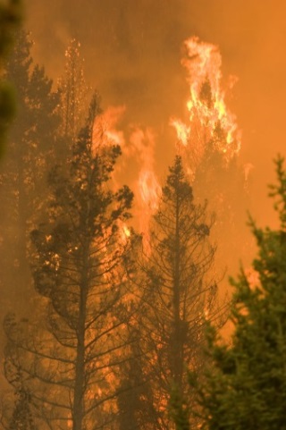
A wildland fire is any non-structure fire that occurs in areas of vegetation or natural fuels, and can be either prescribed fire or wildfire. Wildland fire occurs when vegetation, or “fuel,” such as grass, leaf litter, trees, or shrubs, is exposed to an ignition source and the conditions for combustion are met, resulting in fire growth and spread through adjacent combustible material. Wildland fires are either ignited by lightning or by some consequence of human activity. In Colorado, lightning accounts for only 17 percent of wildfires, with human ignitions accounting for the remainder (Colorado Natural Hazards Mitigation Plan, 2013). Human causes vary and can include escaped debris pile burning, campfires, fireworks, construction sparks, downed transmission lines, and arson.
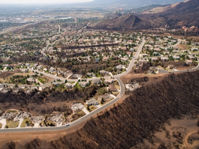 The introduction and increasing growth of development adjacent to and intermixed within the natural vegetation across the landscape poses additional risk to people and property. In the context of wildfire, the combustible components of buildings, infrastructure, and associated accessories make them susceptible to ignition and are also considered fuel for the fire. A fire burning in this situation has transitioned from a wildfire to a wildland-urban interface (WUI) fire, where a combination of vegetation and man-made structures provide fuel for the fire. This situation increases the complexity, cost, and risk of wildfire in Colorado. In most WUI fire situations, fire suppression resources are quickly overwhelmed and multiple structures are lost.
 Wildfires are distinct from other natural hazards in two ways:
- Wildfire activity is not limited to natural environmental causes (such as earthquakes, tornados, or hurricanes) because ignition can also result from human activity;
- Humans have the ability to significantly reduce wildfire threat by altering, redirecting, or (in some cases) extinguishing a wildfire.
 Between 2010 and 2014, an average of 1,192 wildland fires, excluding prescribed fires, occurred annually in Colorado. The number of acres can vary greatly; for example, in 2014, a reported 24,949 acres burned throughout the state, while in 2012 a total of 246,445 acres burned due to wildland fires. Annual structural losses across the state also fluctuate. Between 2012 and 2013, more than 1,200 structures were damaged or destroyed by wildfires that swept across the state, resulting in nearly $1 billion in property damage (Badger, 2015). Other years, however, have reported significantly fewer structural losses and damage.
Wildfire size (reported as acres burned) is not always indicative of its impact. The Royal Gorge Fire that began on June 11, 2013 outside of Cañon City, burned a total area of 3,218 acres and destroyed 90 percent of the Royal Gorge Bridge and Park. The Royal Gorge Bridge itself was relatively unaffected, but 48 of 52 buildings—including the visitor center, Aerial Tram, Incline Railway, and other attractions—were destroyed (Royal Gorge Bridge, 2014). Examples like this illustrate the long-lasting impacts that wildfires can have on the local economy and the variety of community values at risk.
CoreLogic, a national provider of financial and property information, estimates that Colorado ranks as one of the leading states across the western United States in terms of residential properties potentially at risk of future wildfire damage. A 2015 report shows that Colorado has nearly 100,000 homes that are either at high or very high risk of wildfire – translating into $28 billion of residential assets exposed to potential future wildfire damage (Botts, et al., 2015).These trends also reflect a larger pattern associated with increased development in wildfire-prone areas in the West. Community wildfire risk will continue unless more action is taken to reduce and/or mitigate the threat.
Other hazards can contribute to the potential for wildfires or can influence wildfire behavior:
- High winds can down power lines (providing an ignition source), and/or result in areas of downed and dead trees (increasing fuel loads); high winds can also produce rapid rates of spread on active fires and increase the distance of ember transport beyond the active fire perimeter.
- Floods, landslides, and avalanches can result in areas of heavy fuel loading.
- Earthquakes can crack gas lines, creating a higher potential for ignition.
- Lightning can ignite fuels, resulting in wildland fires.
- Drought conditions increase wildfire potential by decreasing fuel moisture. Warm winters, hot and dry summers, severe drought, insect and disease infestations, years of fire suppression, and growth in the wildland-urban interface continue to increase wildfire risk and the potential for catastrophic wildfire in Colorado (Colorado Natural Hazards Mitigation Plan, 2013, p. 3-214).
Generally, wildfire risk is assessed through combining the following:
- Ignition probability
- Fire behavior potential
- Vulnerability of the values at risk to direct fire impingement (convective and radiant heat from the fire front) and indirect ignition (airborne embers transported ahead of the fire perimeter)
Non-Specialists and the Hazard Identification and Risk Assessment
Wildfire hazard identification and wildfire risk assessments require specialized expert knowledge. Non-specialists, however, play an important role in the process. For example, community planners provide necessary information to help identify community values at risk, planned areas of future growth, key demographic trends, emergency response access and evacuation routes, and other features.
As another example, a public works director can provide information on critical infrastructure and planned capital improvements. By participating in the risk assessment process, non-specialists from other departments and/or agencies contribute knowledge and can better understand how wildfire may potentially affect future community risk.
Colorado communities have access to several sources of wildfire hazard data that are useful for identifying wildfire hazard areas and determining community vulnerability to the hazard.
Colorado State Forest Service (CSFS)
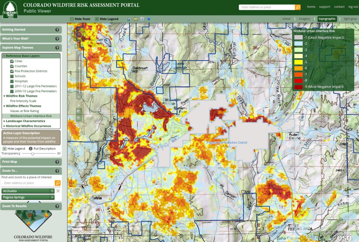
The CSFS is the lead state agency for providing information on wildfire risk and mitigation. The Colorado Wildfire Risk Viewer is the primary mechanism for CSFS to deploy risk information and create awareness about wildfire issues across the state. A public and professional viewer is available online for free (note: anyone can sign up for the professional viewer, which provides additional detail to aid community wildfire planning). CSFS also promotes multiple programs to help reduce wildfire threat, and provides technical assistance to counties, communities, and residents.
In addition to the tools and strategies cited below that are included in this guide, landscaping requirements are also important tools for reducing potential risks from wildfire. Landscaping standards often address issues such as plant material selection (e.g., requiring low-water, native vegetation) and the location of new plant materials installed as part of new development.
|
Addressing Hazards in Plans and Policies
|
|
|
|
|
|
|
|
|
Improving Site Development Standards
|
|
|
Improving Buildings and Infrastructure
|
|
|
Enhancing Administration and Procedures
|