Table of Contents
Earthquakes are the vibrations or shaking created when large blocks of the earth’s crust move against one another. The break between these blocks is a “fault.” Most earthquakes in the earth’s crust occur from movement on faults. Less frequently, some earthquakes are caused by volcanic or magmatic activity (Colorado Natural Hazards Mitigation Plan, 2013, p. 3-153).
Many earthquakes in Colorado occur naturally; however, they can also be caused by human actions. Humans may trigger earthquakes through different types of activities including oil and gas extraction, reservoir impoundment, fluid injection, or mining.
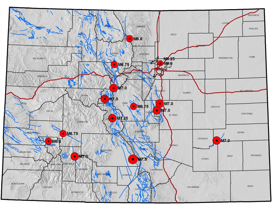
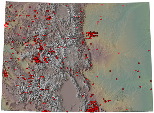
Although many of Colorado’s past earthquakes have occurred in mountainous regions, some have been located in the western valleys and plateau region or east of the mountains. Thousands of faults have been mapped in Colorado, but scientists think only about 90 of these have been active in the past 1.6 million years. Portions of the state have clusters of faults, such as near the Denver metro region, central mountains, and the southwestern and northwestern part of the state. Seismic activity is largely absent in Northeast Colorado.
The Sangre de Cristo Fault, which lies at the base of the Sangre de Cristo Mountains along the eastern edge of the San Luis Valley, and the Sawatch Fault, which runs along the eastern margin of the Sawatch Range, are two of the most prominent potentially active faults in Colorado. Not all of Colorado’s potentially active faults are in the mountains. For example, the Cheraw Fault, which is in the Great Plains in southeast Colorado, appears to have had movement during the recent geologic past. Some faults, such as the Derby Fault near Commerce City, cannot be seen at the earth’s surface.
Even though the seismic hazard risk in Colorado is relatively low to moderate compared to other states like California, it is likely that future damaging earthquakes will occur in Colorado. More than 500 earthquake tremors of magnitude 2.5 or higher have been recorded in the state since 1867. More earthquakes of magnitude 2.5 to 3.0 probably occurred during that time but were not recorded because of the sparse distribution of population and limited instrumental coverage in much of the state (for comparison, more than 20,500 similar-sized events have been recorded in California during the same time period.)
Earthquake events have the potential to trigger avalanches, landslides, soil hazards (liquefaction, uneven ground settling), and flooding caused by the failure of dams, levees or other impoundment structures. Additionally, broken natural gas lines and other pipelines may cause hazardous material releases and often result in structural fires following the event.
Colorado Geological Survey
The Colorado Geological Survey is the primary agency for maintaining Colorado earthquake hazard information.
- The CGS Earthquake page is a one-stop location for finding more information on Colorado earthquakes.
- The Earthquake Reference Collection is a listing of over 500 earthquakes and faulting events that have taken place in Colorado.
- The Colorado Earthquake and Late Cenozoic Fault and Fold Map Server is an online map viewer that indicates where fault lines and folds can be found in Colorado.
Unites States Geological Survey
The United States Geological Survey (USGS) is the primary federal government agency for providing information on earthquakes.
- The USGS National Seismic Hazards Map is a national standard for identifying earthquake hazard zones.
- USGS also maintains a site dedicated to Colorado Earthquake Information.
National Earthquake Hazards Reduction Program
The National Earthquake Hazards Reduction Program (NEHRP) is the federal government’s coordinated long-term nationwide program to reduce risks to life and property in the U.S. resulting from earthquakes.